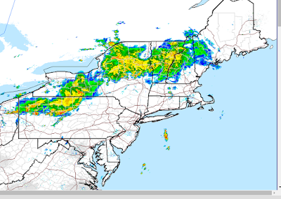
Good morning everyone. It looks like we just might still have the dynamics in place for some pretty big storms as we head into this afternoon. As you walk outside today you will notice how hot and humid it is. Heat index values will reach the mid to high 90's in spots ahead of an approaching cold front that will cause these storms to fire up. Below you can see the current radar scan that shows our area of storms out in PA..
This actually is ahead of the cold front and the timing of this complex vs the crossing of the front will determine how severe the storms get. Regardless, I see enough evidence in place to say SOME areas will see severe storms.
Instability values as projected by all the models still look decent. As a reminder instability measures the temperature of an air parcel compared to its surrounding environment. You want that daytime heating to warm things up and cause that air to rise..
Here is the updated projected instability..
Not every model is showing the same degree of instability but I like I said above I think there is enough evidence to support strong to severe storms. I am not on the bandwagon of an all out severe weather outbreak (more widespread) however.
If we now go to the updated radar projections some pretty nasty storms are popping up this afternoon..
At this point it all will come down to nowcasting. We need to see where the big storm cells develop and what areas they will effect. I think the biggest threat for areas that get hit by the bigger storms will be very strong wind gusts, downpours and some small hail. In terms of tornado development it is not off the table but I do not see widespread support for that.
I will be having updates on twitter today with that information.


No comments:
Post a Comment